

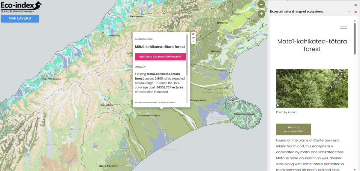
In case you missed it, the Eco-index Ecosystem Restoration Map has been in the news, garnering national coverage from RNZ, The Spinoff, and New Zealand Herald as well as featuring in The Conversation.
Catherine Kirby, Eco-index Communication and Relationships Manager, was hopeful that there would be broad interest in the Ecosystem Restoration Map, but the excitement for the tool exceeded her expectations.
“It’s been great to have loads of engagement with our map,” says Catherine. “It seems to have successfully provided new ecosystem restoration information while adding momentum to the national biodiversity kōrero. We’ve appreciated all the supportive messages and interesting conversations.”
Map users have so far include ecologists, mana whenua, councils, central government, land managers, industry groups and businesses, with many expressing their support for the initiative.

“Te Rarawa is committed to bringing back the mauri of our whenua through our Me He Wai project. This map will add to the information we have about our rohe and support our kaitiakitanga, especially when we’re thinking about restoring local wetlands and kahikatea-pukatea-tawa forest,” said Maihi Makiha (Te Rarawa) Manu Kura for Me He Wai.
“At a national level, there are challenges around biodiversity data collection, access, and sharing,” said Sam Rowland, Programme Manager – Nature, Systems Change at the Sustainable Business Network and co-chair of the Eastern Whio Link. “This map is a good start at fixing those issues and we’re excited to utilise this information for biodiversity strategies and planning.”
Farmers and rural professionals have also expressed support for the map.
“As sheep farmers near Lake Coleridge,” said Jo Johns of Glenthorne Station, “we are very lucky to have many pockets of old and regenerating bush still on our station. This map is going to be a fantastic tool for planning native planting on our farm and the other farms near us. We are trying to regenerate pockets of what should be growing here, so our aim is to reintroduce kahikatea and mataī at lower altitudes.”
More to come from the Eco-index team
While Catherine is happy that there is support for the tool, she hopes for deeper engagement in the months to come as people use information from the map and provide feedback for future iterations.
“This is very much a version 1.0,” says Catherine. “We’re looking forward to making changes that improve the usefulness and functionality of the map.”
The Ecosystem Restoration Map is just the beginning. Eco-index is working on providing a suite of digital products to support land managers to reach their restoration goals.
“With these restoration targets established through our map, land managers will be wondering where to start,” says co-lead John Reid. “They’ll have questions about what’s most affordable and what effort will yield the best value for money. Eco-index is prepared to support decision makers on that journey.”
Alongside the map and its ecosystem restoration targets, Eco-index will be doing staggered releases of further digital tools that together form a digital toolkit. These include artificial intelligence remote sensing ecosystem detectors, a Restoration Heat Map to determine the best places for undertaking ecosystem restoration (based on the priorities of the user), as well as ecosystem restoration costings and ecosystem service valuations.
“These digital tools will help land managers justify expenditures on ecosystem restoration and indicate where biodiversity investment has been successful, for example, in grant applications,” says John.
This digital biodiversity toolkit will be available in 2024, alongside Eco-index analytical services. For updates and to stay informed about the toolkit, we encourage you to subscribe to the Eco-index newsletter. And for those of you who haven’t seen the Ecosystem Restoration Map, please do go check it out!
Jenny Leonard